
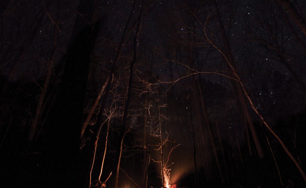
As I climbed into my tent in the most remote location in Missouri, the sky was crystal clear. I left the rain cover off my tent so I could watch as the stars jostled for attention. I had never done that before—I’m not a big fan of getting rained on, and my ratio of nights spent in a tent to nights it rains is 1 to 1. But the performance in the heavens above was too rare and spectacular to be shrouded under nylon darkness, so I gambled that the clear skies would remain just that.
I pulled my sleeping bag snug to my chin and realized that if I leaned a bit left, the roof of my tent framed the Big Dipper perfectly. If I leaned too far, or not enough, the seams on either side of the mesh roof bisected it.
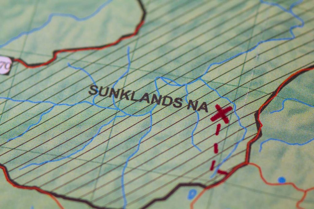
This was the greatest show on earth, and I was the only spectator. I had chosen to camp in this exact spot in the Sunklands Conservation Area in Shannon County because it is the most remote spot in the entire state of Missouri—2.8 miles from the nearest road. I had set out to search for the most remote spot so I could enjoy feeling remote.
It had taken a lot longer than I expected to find that feeling, but in the tent, I finally found it.
How far is ‘far away’?
I was inspired to find Missouri’s most remote location by Ryan and Rebecca Means, scientists from Florida. Along with their daughter, Skyla, they have visited the most remote location in 36 states (and counting) over the last 10 years and catalogued their adventures at ProjectRemote.com.
At almost every single site, they have discovered evidence of humanity, and usually they didn’t have to look very hard. From the most remote spot in New Jersey, for example, they could see the Atlantic City skyline. In South Dakota, they could see a highway. In Arkansas, noise from a roadway kept them up all night. They find this frustrating—proof that development has encroached not only into every inch of our lives but into every inch of our country. They lament the loss of untamed, untrammeled wilderness.
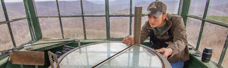
The Meanses define remoteness as “farthest from a road,” and I used that definition, too, to identify Missouri’s most remote spot. I contacted Clayton Blodgett, a geography professor at the University of Missouri, to ask for his help. He used March 2018 data from the Missouri Department of Transportation to zero in on the location that became my camping spot.
When the Meanses identified the most remote location in Missouri in the fall of 2011, they found a different spot than Blodgett found in the spring of 2018. Their location was in Taney County’s Hercules Glades Wilderness Area of the Mark Twain National Forest—about a three-hour drive from the Sunklands. The discrepancy is probably rooted in differences in the sets of data and/or the specific commands given in the search.
Hog wild
I made plans to hike to my spot, knowing that it was quantitatively remote. I hoped it would feel remote, too, an elusive and subjective standard, to be sure. I must confess, my standards of remoteness were not terribly high. I have spent all of my life living near major cities. I am an avid hiker and camper, but many of my camping nights are spent on sites with electricity.
Danielle Stephenson, a resource forester in the state Department of Conservation who is responsible for Sunklands, agreed to drive up from Eminence and give me a tour of the area and guide me to the specific location. Her last email before the trip made Sunklands sound not only remote but ominous: “I do want to give you a heads up that the Sunklands is an area with both feral hogs and bears; also, snakes and ticks are out.”
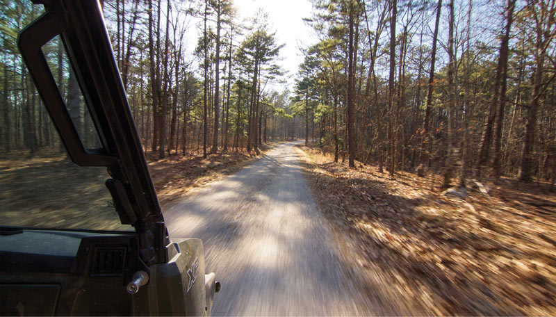
The sense of remoteness started when I read that … and continued during my drive to Sunklands from my home in St. Peters. The remoteness increased in stages. St. Louis radio stations faded to static. Subdivisions gave way to farms. Four-lane highways dwindled to two lanes. Danielle texted me to say she was on her way to our meeting spot and would soon be leaving cell phone coverage area, so if I got lost, I would not be able to contact her. City boy that I am, I doubted her. My phone works everywhere, I thought.
In the same way we went up and down hills, we went in and out of feeling remote. Silence would be our companion until a jet broke it. Gorgeous landscapes were marred by occasional litter, plastic navigating strips tied to trees, and even a “Happy Birthday” balloon that, by the looks of it, was given to a child who is now an adult.
I lost cell coverage a few minutes later.
Without my phone’s GPS to tell me to stop, I missed our meeting spot, even though it was a few feet to the side of Route 19 and Danielle was already there in a giant red pickup truck with a trailer behind it. She might as well have been parked under a blinking neon sign that said, “Stop Here!” but I zipped right by. She had told me that if I got to the Echo Bluff State Park entrance, I had gone too far. When I got to the Echo Bluff State Park entrance, I stopped to ask for directions and soon found her.
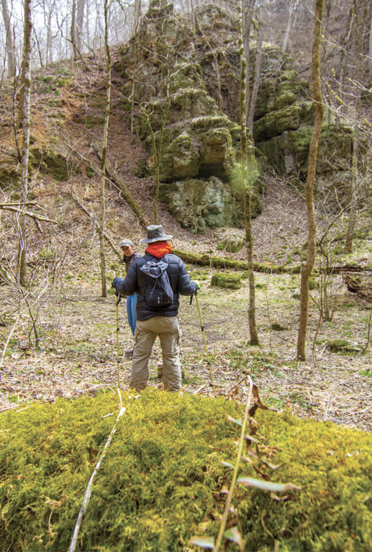
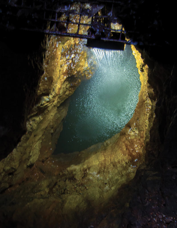
Photographer Evan Henningsen joined us shortly thereafter. Our first stop in Sunklands was The Sink—the deepest and longest sinkhole in the state, the result of a collapsed cave.
On the way down into The Sink, I placed each foot gingerly, as the terrain was loose and rocky. My hiking poles dug deep into the soft earth. We arrived at the bottom in the southwest corner, in a section called Devil’s Den. Standing there was like standing in a soup bowl a mile long, 600 feet across, and 200 feet deep.
If the drive in brought remoteness in stages, so did the hike, though I was often jolted back a few steps. We found the first of at least 10 beer cans in the Devil’s Den. If there’s a bright side to that, it’s that all the cans I saw were Anheuser-Busch products … not that “buy local, litter local” is much of a slogan. One had a pop-top and a bullet hole. “We could pick them up every day and still find them,” Danielle says. “It’s frustrating.”
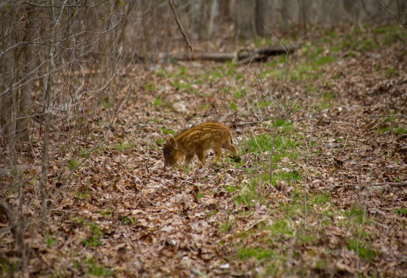
We blazed our own trail within The Sink. As I munched on beef jerky, I saw what I thought was a hedgehog/squirrel/
beaver-type creature about 50 yards away, running toward us on a trail. Could that be one of the feral hogs Danielle warned me about? It was so small that I almost didn’t point it out for fear of looking foolish. It must have been just as confused about us as I was about it. It looked at us, standing stock-still long enough for Evan to get out his camera, put on the right lens, aim, focus, shoot, take a few steps forward and shoot some more. Then the animal turned sideways—in profile, it was unmistakably a hog—before running away.
It probably rejoined a pack it wandered away from, though we didn’t see any others. “It’s not very often you get that close to them,” Danielle says.
Seeing the forest through the trees
With 40,800 acres, Sunklands Conservation Area is the biggest conservation area in Missouri, and after six hours, it felt like we had hiked over each and every one of those acres. By the end of our hike, because of Danielle’s patient teaching and passion for the topic, I could identify white oak, post oak, and shortleaf pine trees by their bark. (The differences between black and scarlet oak remained elusive to my eye.) We covered 6.59 miles and gained 1,180 feet in elevation—all of it in small chunks as we ascended ridge after ridge on our journey from The Sink to the most remote spot.
Up and down, up and down—it would have been repetitive if not for the changes in the landscape. One hill showed obvious signs of fire damage (the most recent was in November 2017), the next was pristine. On the way down one hill, thousands of small white rocks threatened to roll my ankles, and this after hours of walking on rock-free ground.
We stopped three-quarters of the way up a west-facing slope, and Danielle tapped a shin-high stump with her foot. It was the remnants of a shortleaf pine, a tree once valuable for producing railroad ties. Public and private conservation partners are working to restore the shortleaf pine/oak woodlands decimated by logging a century ago.
At the top of another ridge, we walked into a mystery—a charred stretch of ground, far more black than anything else we had seen, as crisp as a police chalk outline. It almost looked like something had exploded there. Danielle guessed that the tree that left this scorched earth had been long dead and dried out so it burned hotter than anything else.
Take only pictures; leave only … body prints
In the same way we went up and down hills, we went in and out of feeling remote. Silence would be our companion until a jet broke it. Gorgeous landscapes were marred by occasional litter, plastic navigating strips tied to trees, and even a “Happy Birthday” balloon that, by the looks of it, was given to a child who is now an adult.
Still, as we reached the most remote spot, I harbored a naive dream that we would be the first people to ever stand right there. For a few seconds, as I spun around surveying the location, it looked like I might be right. We are really far away from everyth—
And then my reverie ended. Ten feet away, I saw a metal brace nailed to a tree. Hidden in the leaves next to the tree was a corroded ladder. The most remote place in Missouri was in the shadow of a deer hunter’s tree stand. Not only had someone surely stood right there before me, but that someone had probably killed a deer there, too. I was more disappointed than surprised, but I was glad, in a way, because at least the stand served as evidence that people had enjoyed exploring Sunklands as much as I had.
As we looked for the best place to pitch our tents, Evan found a mound, maybe 4 feet across and a foot high, whose origin we couldn’t figure out. I wondered if there was something buried under there—the remnants of a gutted deer that a hunter decided not to carry out. Whatever its origin, the mound made a great place for a fire. We made tea from a nearby sassafras root. It was easily the best sassafras tea I’ve ever had at the most remote location in Missouri.
Evan and I talked as darkness fell. I listened to the crackle of the fire and thought about our journey to the quantitatively most remote location in Missouri. Sitting there, I felt a renewed sense of the qualitative remoteness that had come and gone all day.
I climbed into the tent and the silence swallowed me. Then the Big Dipper walked out on stage as if it were putting on a show just for me. I woke up a few hours later, and clouds had rolled in. The temperature had dropped, too, so I put the rain fly on to capture my body heat. I crawled back into my sleeping bag, and a few minutes later, it started raining. I stayed remote and dry. I fell asleep, content that I was as remote as I have ever been … and maybe ever will be.
The sun woke me up the next morning. When I rolled up my tent, I saw my body had left an indentation in the thick leaves that carpeted the ground. I can only imagine the confusion for the next people seeking remoteness when they find that.
Photos by Evan Henningsen
Related Posts
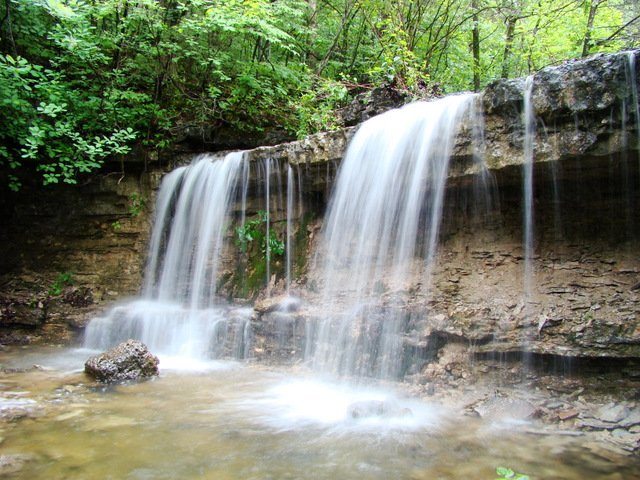
7 Missouri Waterfalls
A haven for gorgeous scenery, the Ozarks is brimming with stunning waterfalls. April and May are great months to enjoy our waterfalls, as water flow is at its peak from spring showers.
10 Books on Missouri’s Native American History
Looking for more reading on the Osage and Missouria tribes? Parts 2 and 3 of our special series are forthcoming in September and October, but in the mean time we highly recommend this selection of books that cover the subject.

Pickleball Is Taking Missouri By Storm
It took about a decade for pickleball to sweep Missouri. With more than 100 locations developed since 2010, Missouri might just have the fastest-growing pickleball community in the country.