
Interstate highways radiate from Kansas City like the 19th-century highways of the Santa Fe, Oregon, and Boone’s Lick Trails. Interstates 35, 49, and 29 all run north and south through the western edge of the Show-Me State. They cross grasslands and cropland; trees appear mostly along rivers and streams. Cattle ranches and livestock sale barns line these routes. Billboards advertise “Western Wear” and images of giant gunslingers direct travelers to car dealerships at gunpoint. In the small towns that connect to these highways, cowboy hats are as common as the ball caps adorned with agricultural logos, and cowboy boots outnumber Birkenstocks.
As you drive these trails of western Missouri at 70 mph in the comfortable climate control of your modern vehicle, consider how different travel was for folks bumping and rocking along dusty trails holding onto reins rather than a steering wheel. We’ve come a long way in a mere 150 years!
Yet, maybe some things haven’t changed. Much like today, 19th-century dads probably didn’t want to stop for anything or anybody until they reached their final destination, either. Moms distributed snacks, and children asked incessantly, “Are we there yet?” Another thing that probably has not changed is that they, like you, enjoyed discovering interesting sights along their interstate trail. Hitch a ride with us as we explore these sights in part three, the final installment of our series on treasures along Missouri’s interstates.
I-35: Build Up & Burn Down
AN ARTFUL WELCOME
Mile 112.4
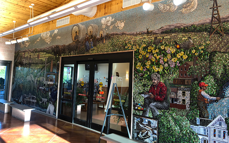
Every state has Welcome Centers, but few, if any, have a Welcome Center as artsy as the Eagleville Welcome Center. Folks traveling into Missouri on Interstate 35 from Iowa are greeted with a stunning 500-square-foot glass tile mosaic titled Prairie Passage depicting iconic people and places in Missouri’s history. It took artists Carl and Sandra Bryant four months to install this 600,000-piece mural. Travelers wishing to stretch their legs awhile can try to identify Missourians such as Jesse James, Harry Truman, Thomas Hart Benton, or Coleman Hawkins. Or, try to find the Pony Express Museum, Albrecht-Kemper Museum of Art, the Liberty Memorial, Watkins Woolen Mill, or the steamboat Arabia, all places located near western Missouri interstates.
One of the 22 mural scenes is of the nearby Dunn Ranch Prairie and the resident prairie chickens. Dunn Ranch Prairie is a spectacular 3,680-acre preserve hosting one of the few remaining populations of prairie chickens in Missouri, a herd of more than 100 bison, and countless rare prairie wildflowers. Find directions to Dunn Ranch Prairie and information about the remarkable spring prairie chicken “booming” rituals at the Welcome Center information desk.
Discover more art outside the center where sculptures of bison and an American Indian on horseback are scattered throughout a restored prairie. The prairie, sculptures, and the Prairie Passage mural will whet your appetite to see Mother Nature’s glorious artistic creation on the canvas of Dunn Ranch and other Missouri prairies.
THE TOWN THAT BURNED
Mile 78.2
This exit will take you into New Pattonsburg—Old Pattonsburg is 2.5 miles southwest of here. You see, the whole town packed up and moved in 1993—the year the great flood swamped the central United States. Situated between the Grand River, Sampson Creek, and Big Creek, Pattonsburg residents were accustomed to frequent flooding. But in July 1993, the Grand River crested at 37.6 feet, more than 12 feet above flood stage. Cows were hoisted up to safety in haylofts, pigs were found perching precariously on dining room tables, and walls of homes crawled with frogs trying to escape the deeper water. It was one flood too many. The federal government offered the residents money to pack up their homes and roll them to higher ground. Twenty-four houses rolled out and residents built more homes in the new town.
So what do you do with a ghost town? Oscar-winning filmmaker Ang Lee had an idea. The director of such movies as Crouching Tiger, Hidden Dragon, Life of Pi, and Brokeback Mountain needed a downtown he could destroy, so he bought the town for $11,000 and made it the setting for a movie based on a book about William Quantrill and his raiders during the Civil War. In 1999, Lee began filming Ride with the Devil, starring Tobey Maguire and Jewel. The day they filmed the scene of Quantrill’s raid on Lawrence, Kansas, was one of the most dramatic. Actors roared down Main Street on horses with guns blazing and two Pattonsburg buildings went up in flames. Many residents of Pattonsburg portrayed extras in the movie. After getting shot down on their old Main Street, they returned as spectators and watched as Hollywood torched their town.
I-29: Big Rigs, Big Birds & Big Hills
A FAMILY PLACE
Mile 36
It’s not every day that you see a semi-truck suspended in midair. But since the Farris truck stop opened in 1974, that’s what travelers witness at the Faucett exit of Interstate 29. The Farris family knows that putting your business on a billboard brings in customers, but using your business as the billboard is even better. Next to the highway, a full-size 18-wheeler sits atop steel poles—a big rig billboard. In its early days, the truck’s headlights were even rigged up to turn on each night. The Missouri Department of Transportation told Gene Farris that the billboard was not allowed, was a distraction, and must be taken down. However, it’s technically not a billboard—and so the big rig has weathered storms for 45 years now. It is fitting that Farris Truck Stop sits between Kansas City and St. Joseph, two jumping off points along the Missouri River for pioneers who headed West in the mid-1800s and where Conestogas—the freight trucks of the day—would travel west with goods.
Today, the Farris children own the truck stop. One family member runs the truck stop, one owns the restaurant, and a third owns the Barlow Trucking business. The restaurant has family connections of its own. “We’re family and we like to treat others like family,” Jeremy Ledford says of their customers. Jeremy is the head cook and his sister, Trinity, is a waitress. Many customers are regulars, but truckers from all around the country know the restaurant from the notable big-rig sign. Celebrities such as Dolly Parton, Kenny Rogers, Motley Crew, Clint Black, Wynonna Judd, and Martina McBride have enjoyed Jeremy’s cooking and caring service from hostesses like Candace.
One year, an icy I-29 stranded travelers for many hours. The truck stop became a haven. “Some of them were just exhausted and needed a place to rest. We let them sleep in our booths right here,” Jeremy says, pointing to one of the tables. “I stayed here 24 hours and we served them coffee, food, whatever they needed.” When you’re on the road for hours, alone and tired, it’s comforting to know there’s a place that welcomes you as family. A place where you can get a hand-cut steak, hand-breaded tenderloin, and made-from-scratch pie. A place where family extends beyond business.
DUCK, DUCK, GOOSE
Mile 80.4
If you notice more ducks and geese flying overhead for the next few miles, it’s because you are cruising past the Loess Bluffs National Wildlife Refuge near Mound City. Look off to the west to see a fragmented tree line that circles the 10-mile loop around the refuge and a glimpse of some of the pools on the 7,440-acre refuge. Established in 1935, the refuge is a place for migratory birds and other wildlife to find food, shelter, and a place to raise their young.
During Ron Bell’s 27 years as refuge manager, he saw the bald eagle removed from the list of threatened and endangered species and he
cheered with his staff in 1997 when the first eaglet hatched in a nest on the refuge. Today the refuge hosts hundreds of wintering bald eagles and more than a million snow geese. Tens of thousands of geese and ducks rest here alongside flocks of sandhill cranes and trumpeter swans on their long migration journeys. Many other species of birds, mammals, reptiles, and amphibians thrive year-around on the refuge.
Originally named Squaw Creek National Wildlife Refuge, after the creek by the same name that you’ll cross a few more miles north, the refuge is now called Loess (pronounced luss) Bluffs after the beautiful bluffs just behind the refuge headquarters and seen on the east side of I-29 from St. Joseph into Iowa. These loess hills started forming more than 100,000 years ago after glaciers began scraping the land as they moved south. When the glaciers melted and the land dried, the wind would pick up the very fine silt left behind and blow it west where it began to pile into hills that grew over thousands of years of periodic glaciation. The thickest loess bluffs in the world are found only in this region and along China’s Yellow River.
Loess Bluffs NWR is one of the most beautiful places in northwest Missouri to watch the sunset. From high on a loess hill you can look west out across wet acres that reflect twilight bands of purple and gold, the colors broken by rivers of waterfowl on the wing.
LEWIS AND LOESS
Mile 122.2
You get up close and personal to these loess hill giants just beyond mile 122.2 near where Meriwether Lewis first described the hills and prairies on his journey with William Clark. On July 16, 1804, Lewis rode his horse along the Nishnabotna River, a tributary of the Missouri River;
you cross the Nishnabotna less than a mile north of here. After spending the previous two months exploring the plants and animals of Missouri, Lewis looked across the prairie toward these loess hills and exclaimed it was “one of the most beautiful, level and fertile prairies that I ever beheld.” On their last full day in what is now Missouri on their journey west, the explorers called this very area the “bald-pated prairie” with the “bald hills” in the background.
Today the Missouri Department of Conservation manages this as the Star School Hill Prairie, named after the little one-room Star School that sat at the base of this hill from 1889 to 1948. The department monitors the native prairie’s plants, insects, and other creatures so that the rich ecosystem appears almost exactly as it was when the country’s first explorers gazed upon it. Arid, sun-loving plants such as soapweed yucca, dotted blazing star, and hairy grama grass, usually found more than 100 miles west of here, thrive on these loess hills. Some call the narrow ridge peaks saddles because the long sloping hills look like the backbone of an animal.
Although there are no marked trails, you are welcome to explore this conservation area, wander among native prairie plants, beneath gnarled sprawling bur oaks, and upon these hills of baby-powderlike fine soil to get an amazing view across the fields and floodplain to the west.
I-49: Mail Call, Memories & a Man Cave
A PECULIAR NAME
Mile 167
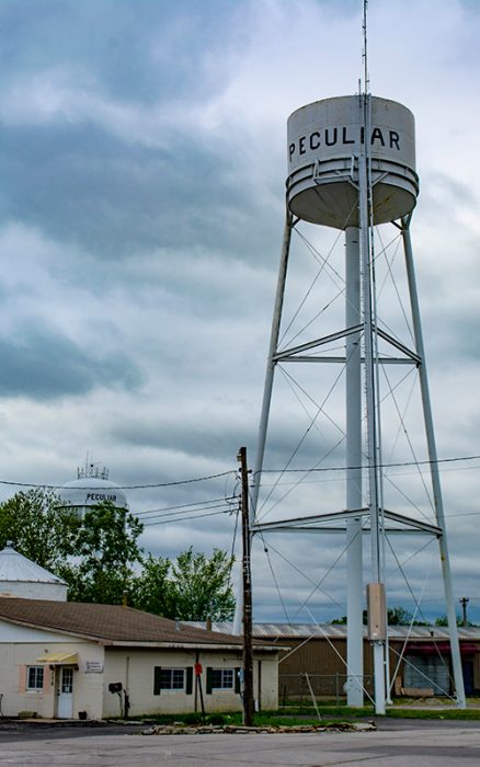
At exit 167 of Interstate 49, you can visit a town with the peculiar name of Peculiar. Like most people passing by on the interstate, you probably wonder how a town ended up with such an unusual name. Although more than one explanation has been published, the most widely held version is as follows: In the 1800s, a town was not really a town unless it had a post office, and the postal service had to approve the name to avoid confusion associated with more than one town having the same name. By the time settlers moved into western Missouri, many names were already taken by older towns further east. The folks here submitted three names for their settlement, but all three were rejected because they had already been taken. Frustrated, they wrote directly to the postmaster general and said they would let him choose the name. Their only guidance was, “We don’t care what name you give us, so long as it is sort of peculiar.” The postmaster general replied that after serious consideration of their predicament, “My conclusion is that in all the land it would be difficult to imagine a more distinctive, a more peculiar name than Peculiar.” And so on June 22, 1868, the post office of Peculiar, Missouri, was established. Check out Peculiar and you will find that it is a pleasant small town of about 5,000 people and not peculiar at all.
MISSOURI’S BEST-KEPT SECRET
Mile 141
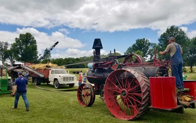
“The best-kept secret in all of Missouri” is how Bill Reitz refers to Frontier Village, located at the southeast corner of the intersection of I-49 and Route 18. Bill is president of the Western Missouri Antique Tractor & Machinery Association, the group that established the Frontier Village on this 29-acre site in Adrian in 1984.
From the interstate looking east, you can see several buildings, some antique construction equipment such as a horse-drawn road grader, and the tracks for a small-gauge railroad ride called the South Prairie Railroad. Exiting for a closer inspection reveals more than 20 buildings including the Old Spruce Mercantile, Raging Lions Saloon, the Mt. Vernon one-room schoolhouse, Uncle Bill’s red barn, and the Mulberry Church. Visitors also will see the largest steam engine and oldest portable running steam engine in Missouri. But, Bill says, the 250 association members are proudest of the Frontier Village Museum. Interstate travelers visiting the museum will take a trip through the past as they see many antique household appliances and other items to conjure up nostalgic memories.
The museum is open on the second and fourth Saturdays of the month between May and August, by request with the rental of the Village Hall, or during the many annual special events. These include Hot Chocolate Night in November, a holiday light show during the Christmas season, and the Antique Tractor and Machinery Show in June. At this latter event, several thousand visitors from 20 states come to witness plowing, threshing, baling, and craft demonstrations, ride the model train, and get up-close looks at two sawmills, including an operational 120-year-old mill moved in from Clinton. Frontier Village is the result of dedicated volunteers committed to preserving history and western Missouri’s proud agricultural heritage. The secret is getting out!
‘MAN CAVE’ ON RAILS
Mile 133.2
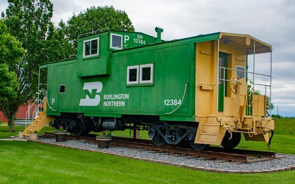
Never underestimate the power of a school field trip to change lives. The green and yellow Burlington Northern caboose in a yard along I-49 at mile 133 is the direct result of Richard McLain’s fifth-grade field trip. Richard’s class took the train from Chillicothe to Chicago and this trip fostered a love of trains that has extended into adulthood. Richard noticed how many small towns have a caboose sitting in a city park and that inspired him to look into getting his own caboose. He found it rather easy to purchase one and to get the necessary tracks and ties. The hardest part of the project was convincing his wife that they needed a caboose in their yard. She thought he was “crazy.”
The local railroad running through Bates County gave Richard two 50-foot rails. He connected ties to the rails. A company that specialized in reclaiming train derailments moved the caboose to his yard and two cranes moved it into position. Raccoons, opossums, and wasps had been living in the caboose for years so the inside required a complete remodel. But rather than restore it as a caboose, Richard had a better idea. He knew many guys who had “man caves” in their basement, garage, or shed. He decided to combine his love of railroads with a desire for a man cave. He remodeled the inside to have a bar, kitchen, and bathroom and turned it into a great place to watch games with friends. His skeptical wife now hosts a group of women called the “Caboose Crew” who get together regularly to drink wine and socialize in the caboose. The caboose was even featured in an episode of The History Channel’s God, Guns, and Automobiles.
If you stop on the shoulder to take a photo of the caboose, you are not the only one. A local state trooper told Richard that almost every day he sees people pulled over and when he stops to see if he can help them they invariably say they are just photographing the caboose. The fifth-grade field trip has spread much joy not only to Richard, his skeptical wife and the Caboose Crew ladies, but among travelers on I-49.
 I-55 and more!
For an experience much different from driving the western Missouri interstates, cross over to the other side of the state and travel south from St. Louis on Interstate 55. This highway hugs the Mississippi River and connects the charming historic towns that grew up along the river. The most notable of these towns is the former French settlement of Ste. Genevieve, the oldest town in Missouri. As you descend into the Bootheel region, you’ll think you’re in the Deep South surrounded by fields of cotton and rice. And, before leaving Missouri, you will pass by New Madrid, the epicenter of the most powerful earthquake in US history. You’ll also drive by Mingo National Wildlife Refuge which like the Loess Bluffs Refuge in the west, provides habitat for waterfowl and other wildlife. This heavily wooded refuge looks very different from Loess Bluffs as it is mostly bottomland forests and cypress swamps rather than open marshes.
Other short interstates such as I-64, which crosses the greater St. Louis metro area, and three-digit interstate spurs or loops move traffic in and around major urban areas.
Interstate highways were never meant to be scenic byways. In fact, President Dwight D. Eisenhower initiated the Federal Interstate Highway System because as a general he knew the value of being able to move military personnel and equipment efficiently cross-country. And with the threat of nuclear war on everyone’s mind in the 1950s, Eisenhower wanted to provide a means of quickly evacuating cities. So as the topography and local politics allowed, interstates were built in the straightest and shortest routes between cities, rather than the most scenic. But if you look again with renewed vision, you’ll see there is much to enjoy along Missouri’s interstates.
Related Posts
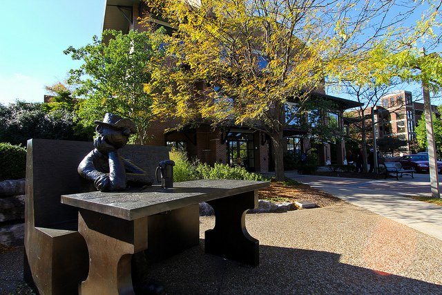
September 3, 1923
Cartoonist Mort Walker, creator of Beetle Bailey, and loyal University of Missouri Alum was born on this day. Beetle Bailey’s Camp Swampy was modeled after Missouri’s Camp Crowder where Mort Walker had been stationed.

Pickleball Is Taking Missouri By Storm
It took about a decade for pickleball to sweep Missouri. With more than 100 locations developed since 2010, Missouri might just have the fastest-growing pickleball community in the country.