
The paved interstate may not be the prettiest of highways, but the journey along these high-speed expressways brings inspiring stories in a beautiful landscape just outside your car windows. In the grand tradition of Route 66, the road becomes a thread that ties the stories of Missouri communities together. Join us in this second installment of our series as we continue celebrating lives and landscapes at 70 mph along the interstate highways of the Show-Me State.
Interstate 44 crosses Missouri from St. Louis to the Oklahoma state line, just west of Joplin, a length of 293 miles. For 235 of those miles, from St. Louis to Halltown, I-44 follows the route of what John Steinbeck called America’s “Mother Road”—the legendary Route 66. As the classic song promised, you can still “get your kicks on Route 66” as you travel along I-44.
For much of this trip across Missouri, you will travel through the Ozarks. In this region, you’ll witness a landscape characterized by a geologic feature called “karst” that lends itself to the formation of caves and crystal-clear springs. In fact, I-44 links three of Missouri’s most spectacular caves: Meramec Caverns (exit 230), Onondaga Cave (exit 214), and Fantastic Caverns (exit 77). Here some other fascinating sites to visit while traveling east to west along I-44.
A PHARMACY IN THE FOREST
Miles 288–287
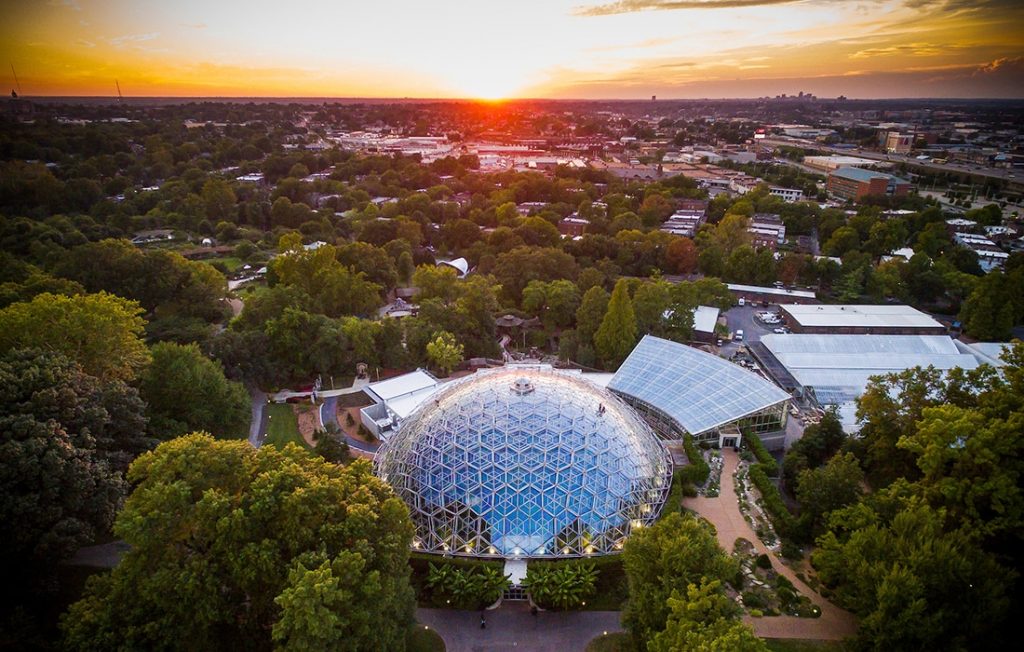
That glowing dome you see in the distance while driving near exit 287 at night is not an alien spacecraft; rather, it is the Climatron greenhouse at the Missouri Botanical Garden. Each day, thousands of people drive by Missouri’s own little slice of Eden located on the south side of I-44. Most don’t realize they are driving past a world-famous institution and the nation’s oldest continuously operating botanical garden. The Climatron’s iconic geodesic dome and beautiful gardens with ponds and water features are standout attractions. Some know the garden as a first-class wedding and party venue or associate it with inspiring special exhibitions, seasonal events, school programs, and workshops for families and adults.
The Missouri Botanical Garden is an internationally famous and prestigious research institution. Some research conducted here focuses on tapping into the knowledge of indigenous peoples in South America, Africa, and Asia to find plants with medical uses. Since 1986, garden scientists have collected and studied more than 35,000 plant samples to determine if they have potential as useful drugs. Some plants studied here already have provided drugs to treat pain, hypertension, Parkinson’s disease, certain heart ailments, and many other illnesses including cancer. The National Cancer Institute has identified more than 3,000 plants as sources of cancer fighting chemicals, 70 percent of which come from tropical rainforests. About 25 percent of the prescriptions filled in the United States contain active ingredients extracted from plants found in the Amazon rainforest. Only 5 percent of Amazonian rainforest plants have been analyzed, and with thousands of plants yet to be studied, Missouri Botanical Garden scientists and others are racing against time as the rainforest shrinks.
HOME ON THE HILL
Miles 287–286
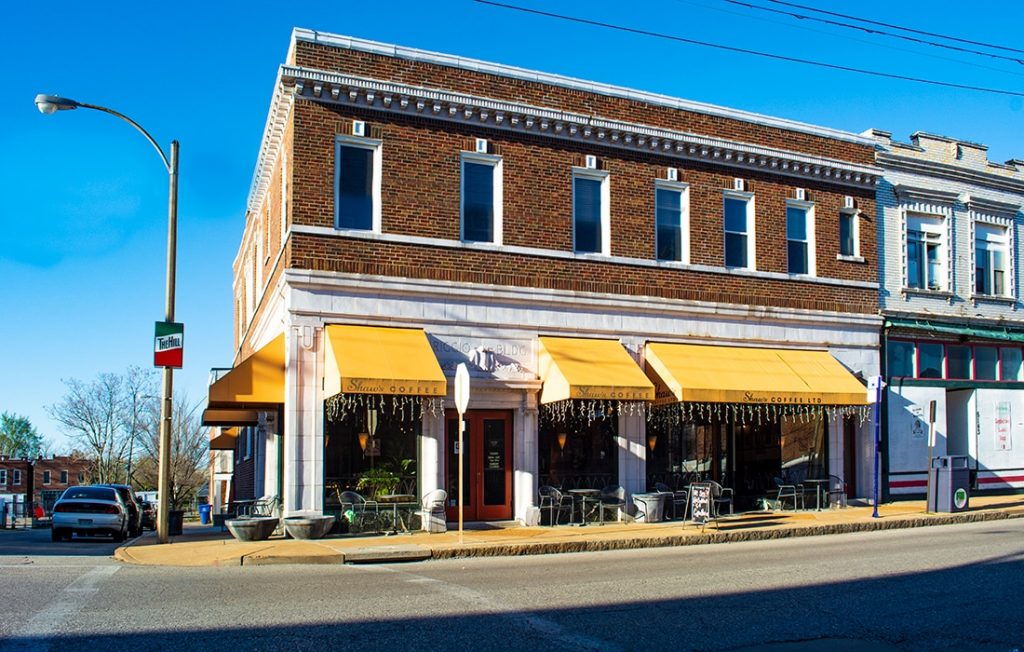
The swish of brooms on sidewalks near well-manicured lawns and tidy little houses, the crack of a competitor’s well-played bocce ball, the fragrances of oregano, garlic, bread, and pastries—all of these Italian sights, sounds, and smells surround I-44 between exits 287 and 286. Throughout The Hill neighborhood of St. Louis, you’ll see the red, white, and green-striped Italian flags painted on street posts, fire hydrants, and buildings. You can even see a few of these from I-44. Italian immigrants established this community when they moved to the highest elevation in St. Louis to work in the clay mines. Baseball greats Yogi Berra and Joe Garagiola grew up in this neighborhood, as did half of the 1950 US soccer team that won the World Cup.
Some of the modest little homes are nestled up adjacent to the highway. That’s because in the early 1970s I-44 cut through this Italian American neighborhood, destroying more than 100 homes in its path. Cracked but not broken, The Hill remains strong to this day. Although the neighborhood is known mostly for its incredible Italian restaurants, the most remarkable strength of this community is the resilience and pride of the people in keeping their neighborhood intact and idyllic for more than a century. Neighbors paid for the construction of St. Ambrose Church, The Hill’s first church, and paid again for it to be rebuilt in bricks after fire consumed it in 1921. When I-44 divided their neighborhood, residents fought to have an overpass built for the safety of their friends and family and the cohesion of the community. You’ll travel under this pedestrian walkway just after mile 286.5 when westbound.
Even today, the community has a strong neighborhood association that continually looks for ways to invite younger homeowners into the community with hopes they will cherish the old neighborhood. Italian language classes, restaurants, and bakeries pass to the next generation, and bits of the Old Country still remain just off the busy interstate.
FOREST 44: THE FIRST FOREST
Miles 271–268
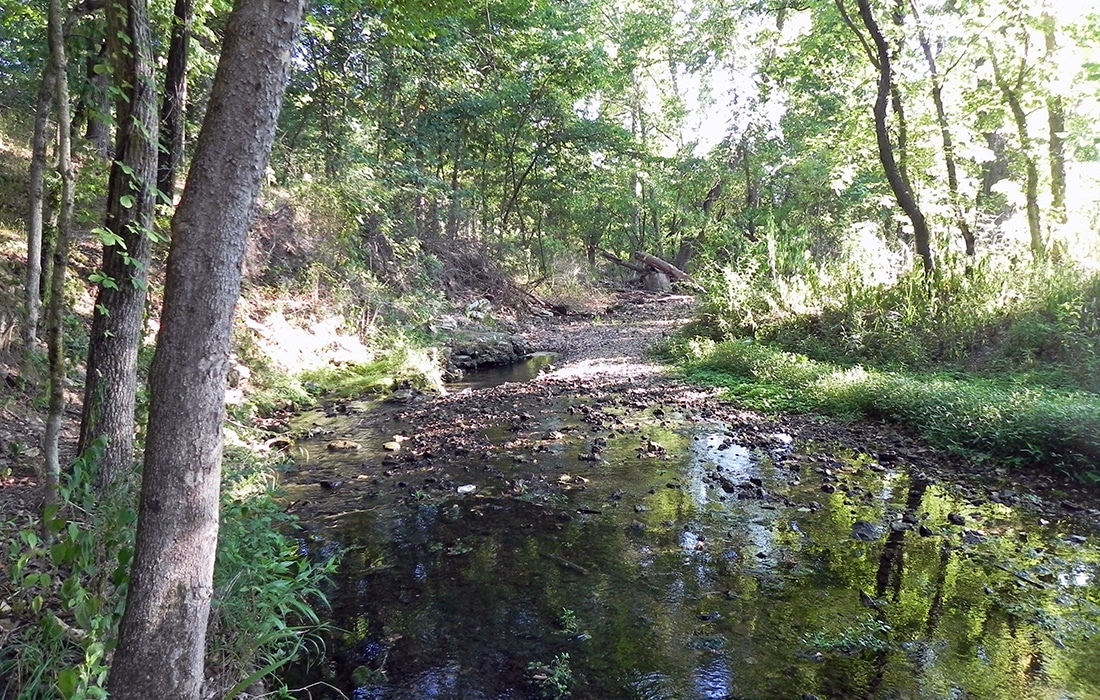
The first forest you see when leaving St. Louis is Forest 44, probably the only forest in the world named after an interstate. Forest 44 also marks the northeasternmost limit of the Ozarks, and the rocks, plants, and animals found here are typical of Missouri’s Ozark region. For three miles here, the rugged terrain of Forest 44 slopes down to the south side of I-44. Forest 44, a 998-acre conservation area managed by the Missouri Department of Conservation, offers 13 miles of horseback and hiking trails, including a wheelchair-accessible path, so everyone can get outside and experience the forest’s beauty up close.
Timber once covered 70 percent of Missouri, but demand for fuel for wood-burning riverboats and locomotives, as well as the need for thousands of railroad ties and other wood products, led to the cutting of most of Missouri’s forests. Today, forests cover about 30 percent of the state, and Missouri’s forest products industry is thriving as it provides more than 33,000 jobs and contributes more than $3 billion each year to the state’s economy. Woodlands like Forest 44 provide homes for wildlife, recreation opportunities for outdoor enthusiasts, cleaner air and water by capturing pollutants, and beautiful foliage in summer and fall. But you “woodn’t” believe what else comes from Missouri forests! Besides the obvious items such as lumber and firewood, Missouri’s forests provide tool handles, gunstocks, fence posts, pallets, furniture, charcoal, barrels, walnuts, cedar souvenirs, and, of course, Christmas trees. Even resin and many other chemicals come from the Show-Me State’s trees. The average American consumes the equivalent of one tree 18 inches in diameter and 100 feet tall each year!
By the way, with the Endangered Wolf Center and World Bird Sanctuary just across the interstate from Forest 44, you are truly surrounded by nature on this stretch of I-44.
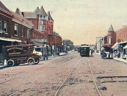
SIX ROUTE 66 RELICS IN 6 MILES
Miles 195–189
From the 1950s through the 1970s, the two lanes of iconic Route 66 through Missouri transformed into four lanes of I-44. Fortunately, you can still recognize many landmarks of the “Main Street of America” from the interstate. An especially nostalgic stretch of Route 66 remnants is between Rolla and St. James. The six miles between markers 195 and 189 offer a glimpse of six sites that once flourished along the Mother Road.
At exit 195, look to the south side of the interstate to see where Route 66 travelers in the 1950s could stay at Finn’s Motel, which invited all to “Rest with us tonight, to drive your best tomorrow.” You can still stay there. If they wanted a balcony view, Mother Road travelers could choose the two-story Gateway Inn Motel, which has been renamed Greenstay Hotel & Suites on the north side of the interstate.
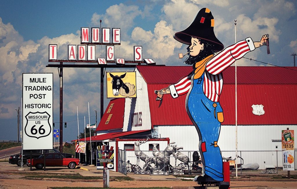
Just past mile 194, look to the north side at a long white house that once was the Rock Haven restaurant and service station. Imagine a few gas pumps in front of the house and six little stone cabins that Rock Haven offered highway travelers for a night’s rest. Today, one cabin, just west of the house, still remains. At mile 192.2, there is a cluster of what are now apartments that was once another Route 66 motel consisting of individual cabins arranged in a semicircle. Route 66 Motors, between miles 191.2 and 191.4, evolved from a 1950s gas station to a souvenir shop over the years, and the Mule Trading Post on the south side of the highway at exit 189 still has its original mule light glowing on the front of the store.
ROADSIDE ROCKS
Miles 153–143
In hilly stretches, construction crews had to level the slope of I-44, creating rock cuts much like cliffs alongside the roadway. These cross-section slices of hills reveal fascinating looks at what is beneath your feet and car. Some of the most dramatic are between Lebanon and Rolla with a particularly steep and deep cut at mile 148.
The Ozark hills are remnants of America’s oldest mountain range. Originally formed as a volcanic area, wind and water have shaped the hills and valleys. You’ll notice if you look at the top of the road cuts that the layer of soil is very thin and rocky. This limits farming to the valleys where good soil has accumulated over time. As you can see, the uncultivated uplands remain mostly forested or in grass pastures for grazing.
Drivers on I-44 cross a region of porous limestone called karst. Karst covers about 59 percent of the state. It is characterized by caves, sinkholes, springs, and underground rivers where much of Missouri’s abundant drinking water flows and gets filtered. The groundwater dissolves soluble rock such as limestone and dolomite, creating the caves and sinkholes. This relationship between rock and water has produced more than 6,300 caves (giving Missouri the name “The Cave State”), 3,000 documented springs where flowing groundwater reaches the surface, and thousands of sinkholes where the rock below the surface has dissolved causing the ground to sink. Greene County alone, which I-44 crosses near Springfield, has more than 2,500 sinkholes. This special geology allows Missourians to enjoy caves, clear rivers and streams, and pure drinking water. It also provides habitat for a wide variety of rare plants and animals that live in caves and springs.
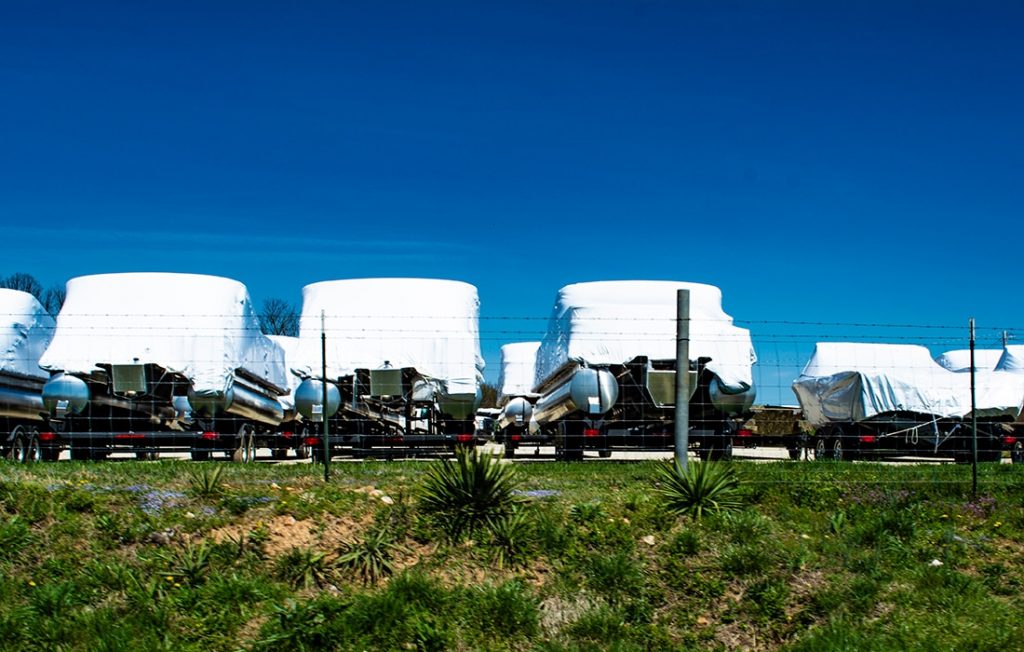
BOAT CITY, USA
Mile 128
You probably don’t expect to see fields full of boats in central Missouri, miles from a body of water, but that is exactly what you see as you pass through Lebanon, Missouri, a.k.a. Boat City, USA. Hundreds of boats, each wrapped in white plastic cocoons, line the interstate awaiting launch. Lebanon is the aluminum fishing boat capital of the world with three of the top five producers located here. According to Brian Thompson, president/CEO of Lebanon Regional Economic Development Inc., manufacturers here produce 50,000 boats each year—primarily aluminum fishing boats with some pontoons and canoes.
Memories of the Mother Road
Route 66 relics survive and thrive along I-44. Revel in the heyday of traveling this beloved route at the Visitor Center in Route 66 State Park at exit 266 near Eureka, the Route 66 Museum in the Lebanon Public Library at exit 129, and an amazing rest stop between miles 110 and 111 at Conway that interprets Route 66 through picnic shelters that are miniature replicas of businesses that were on the famous highway. These include a Phillip’s 66 gas station, diner, barber shop, and barn with Meramec Caverns painted on it. This rest stop not only offers a chance to stretch the legs but also immerses visitors in a celebration of the Mother Road.
Nationwide, 95 percent of aluminum fishing boats purchased in the United States is built in Lebanon! The city is home to manufacturing plants for Tracker Boats, G3, Lowe Boats, Landau Boats, and Osagian Canoes. Tracker, the largest of these, is visible on the north side of the interstate at mile 128.6. G3 is on the south side of I-44 between exits 130 and 129; Lowe and Landau are also on the south side between exits 129 and 127.As you drive I-44, you will undoubtedly pass many trucks carrying these boats on their journey to water.
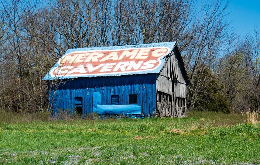
BILLBOARD BARNS
Miles 119 and 114.6
On the west side of the highway north of Conway are barns advertising Meramec Caverns. Westbound travelers can also see one just west of the St. Clair Rest Area back at mile 235. You might be familiar with the spectacular Meramec Caverns near Stanton, the largest commercial cave in Missouri. But you might not know the story of these painted barns. In the 1930s, at the height of the Great Depression, Meramec Caverns owner Lester B. Dill went to Florida looking for construction work. On the way, he noticed barns painted with ads saying “See Rock City” and “Chew Mail Pouch Tobacco.” Lester decided to use barns to promote his caverns.
The original payment for allowing a barn to be painted with the Meramec sign included a railroad pocket watch for the farmer, a box of chocolates for his wife, and a free pass to visit Meramec Caverns for the whole family. The biggest benefit the farmer received, though, was that his barn received a fresh coat of paint! Teams of barn painters would travel the countryside finding barns along well-traveled highways. At its peak in the 1950s, more than 300 barns in 26 states from California to Michigan advertised Meramec Caverns. Today, only about 80 of these Meramec Caverns barns remain.
An interesting side note to the Meramec Caverns history is that this is where bumper stickers were invented. Lester Dill started tying cardboard “bumper signs” onto the bumpers of the visitors’ cars with twine. Soon, he began experimenting with various adhesives. The bumper signs evolved with a wax paper backing that could be peeled back to expose flypaper-like glue. By the 1960s, politicians took hold of the idea and made bumper stickers commonplace.
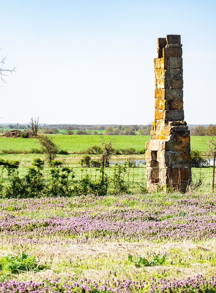
LONE SURVIVOR
Mile 60.4
When driving a Missouri highway, you expect to see barns, silos, tractors, and farm animals. What you don’t expect to see is a house chimney standing all by itself in the middle of crops like a lone tree. But here you will see the surviving old stone chimney of a house that was built more than 150 years ago. Columnist Steve Pokin wrote in the Springfield News-Leader last year that the chimney has been in that spot west of Springfield since the mid-1800s when it warmed the home of Albert Batson’s grandparents. Albert was born on this property many years after his grandfather was murdered just outside the home during the Civil War years.
The chimney has survived the construction of roads and the progress of the tractor. Albert believed that the house was probably gone by the time I-44 came through Greene County in 1962, and he speculated years later that the chimney survived only because work crews had to veer away from that direction to avoid going through nearby Halltown Cemetery. Property owners since have all agreed to preserve the chimney and its history. Whether it still stands as a respected family monument or as a remnant of the Civil War, count this chimney as a personal and public historical marker from Missouri’s past.
A CAPITAL TOWN
Mile 29
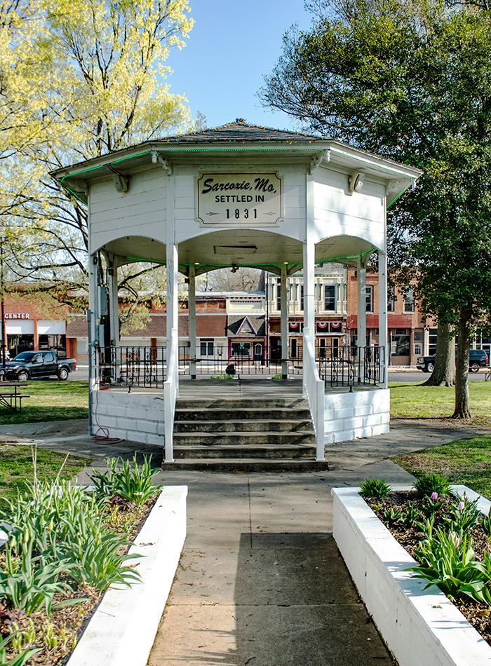
If you look south through the trees just west of exit 29, you glimpse the town of Sarcoxie. At the beginning of the 20th century, Sarcoxie was known as “The Strawberry Capital of the World.” The town even had its own currency with a picture of a strawberry on one side. Local banks would give various-sized tokens, indicating their value, to the local strawberry grower cooperative which then used the tokens to pay migrant workers who came by the thousands to help with harvest every May.
Today, Sarcoxie is known as “The Peony Capital of the World” as it is home to Gilbert H. Wild, America’s largest growers of daylilies, irises, and peonies. When Gilbert Herman Wild’s wagon train to the southwest broke down here in 1868, he was impressed by the lush meadows of colorful wildflowers, so he decided to settle here instead of continuing west. In 1885, Gilbert paid $45 for a crate of peony roots from Europe and he planted them behind his home. Three years later, he sold blooms from those plants and this began his passion for peonies. Today, the company grows 600 varieties of peonies on some of the same land north of the interstate where Gilbert grew his peonies in the 1800s. Although there is no retail store here, visitors are welcome to walk the fields when flowers are blooming and experience acres of glorious color.
HIGHWAY OF HEROES
Miles 179–1
Driving through towns along I-44 with names such as Sleeper and Doolittle, travelers might think that folks are lazy in the Ozarks. Of course, this is not the case. The town of Sleeper was named after a railroad employee who always looked tired, probably from working so hard on the railroad—a noble occupation that helped settle and develop Missouri. And Doolittle was named after the famous US Medal of Honor Army general who fought in World War II and commanded the daring and morale-boosting Tokyo bombing raid of April 18, 1942.
Doolittle is not the only place named for a war hero along I-44. Waynesville, Greene County, Jasper County, Newton County, and Pulaski County are named after Revolutionary War heroes “Mad Anthony” Wayne, Nathanael Greene, William Jasper, John Newton, and Kazimierz Pulaski. Lawrence County is named for James Lawrence, a War of 1812 naval officer known for his battle cry, “Don’t give up the ship!” The American Revolution and War of 1812 were both still fresh in people’s minds when these areas were settled. As Americans moved into Kansas and points west decades later, most towns and counties were named after Civil War heroes.
Related Posts
August 9, 1834
The road from St. Louis to St. Charles was declared a public road on this date. It was laid out in 1772. In 1865 it was improved with a rock surface and has been known as St. Charles Rock Road ever since.

Devon Allman on the Road, on the Rise
When he gets a break, the son of legendary Gregg Allman of the Allman Brothers Band, Devon Allman heads home to St. Charles to recharge.